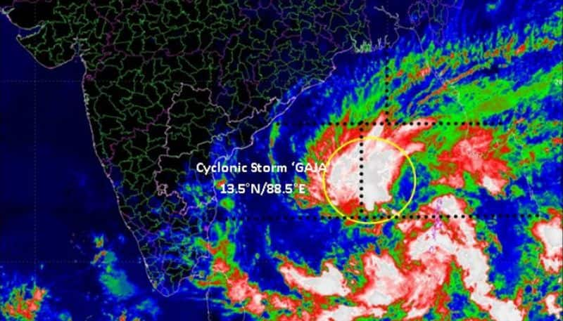
According to the Indian Meteorological Department, Gaja has the potential to turn into a 'severe cyclonic storm' over the next 24 hours
New Delhi: Cyclonic storm Gaja is likely to turn into a ‘severe cyclonic storm’ during the next 24 hours and likely to maintain its intensity for a day and then gradually weaken on November 15, the Indian Meteorological Department said.
Forecast track and intensity of cyclone Gaja:

Source: IMD
Warnings issued
• Gale wind speed reaching 70-80 kmph gusting to 85 kmph prevails over Westcentral and adjoining Eastcentral and South Bay of Bengal. It is likely to increase gradually becoming 90-100 kmph gusting to 110 kmph over southwest and adjoining west-central and the southeast Bay of Bengal from the evening of November 13.
• The sea condition is very likely to be rough to very rough along and off Tamil Nadu-south Andhra Pradesh coasts from November 14 morning and high from the night.
• The storm surge of a height of about 1.0 meter above astronomical tide is very likely to inundate low lying areas of Nagappattinam, Thanjavur, Pudukkottai and Ramanathapuram districts of Tamil Nadu and Karaikal district of Puducherry at the time of landfall.
• Damage expected over districts of Cuddalore, Nagappattinam, Tiruvarur, Thanjavur, Pudukkottai and Ramanathapuram districts of Tamil Nadu and Karaikal district of Puducherry
The CS ‘GAJA’ over Bay of Bengal lay centred at 2330 hrs IST of 12th Nov, 2018 near lat 13.2°N and long 87.5°E, about 780 km east of Chennai (Tamil Nadu). It is likely to weaken gradually and cross Tamil Nadu coast between Pamban and Cuddalore as a CS during 15th Nov forenoon. pic.twitter.com/d3Xnuumirh
— India Met. Dept. (@Indiametdept) November 12, 2018
Advisory
• Total suspension of fishing operations along and off north Tamil Nadu and Puducherry and adjoining south Andhra Pradesh coasts during November 13-15.
• The fishermen are advised not to venture into central parts of south and the central Bay of Bengal on November 13 and into southwest & adjoining west-central Bay of Bengal during November 13-15.
• The fishermen, who are in deep Sea are advised to return to coasts.
• Coastal hutment dwellers are advised to move to safer places. Other people in the affected areas to remain indoors.
Last Updated Nov 13, 2018, 1:04 PM IST


![Salman Khan sets stage on fire for Anant Ambani, Radhika Merchant pre-wedding festivities [WATCH] ATG](https://static-ai.asianetnews.com/images/01hr1hh8y86gvb4kbqgnyhc0w0/whatsapp-image-2024-03-03-at-12-24-37-pm_100x60xt.jpg)
![Pregnant Deepika Padukone dances with Ranveer Singh at Anant Ambani, Radhika Merchant pre-wedding bash [WATCH] ATG](https://static-ai.asianetnews.com/images/01hr1ffyd3nzqzgm6ba0k87vr8/whatsapp-image-2024-03-03-at-11-45-35-am_100x60xt.jpg)


